
PureInsight | September 23, 2023
[PureInsight.org]
Taiwan: Mu Continent Ruins "Sakiyama Pyramid"
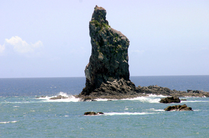
In 1985, a diving tour guide unexpectedly discovered an ancient ruin on the seafloor near the island of Yonaguni, Japan. The site includes ten nearby buildings on Yonaguni Island and five related buildings near the main island of Okinawa, including a castle, a triumphal arch, five temples, and at least one large sports stadium. Roads, waterways, and massive walls connect these buildings together. The total area of the entire site was estimated to be 300 meters by 150 meters.
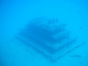
In 1990, divers discovered a huge pyramid-like structure made of stacked rocks off the coast of Yilan, Taiwan, 60 nautical miles away from the westernmost point of Yonaguni Island. This pyramid-shaped structure is 183 meters wide, 27.43 meters high, and composed of rectangular boulders, with five levels. Several small stone pillars were also found near the pyramid, shaped like miniature pyramids with steps made of stone slabs. They are about 10 meters wide and 2 meters high. The shape of the Sakiyama Pyramid is similar to the "Makimuku Iseki" in Nara's Asuka region, as well as the Mayan pyramids in Mexico, located across the Pacific Ocean.
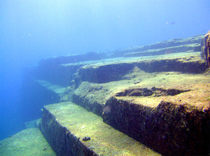
Geologists have stated that the series of massive steps made of one-meter-high stone blocks form a type of step pyramid. However, the sharp-edged step profiles cannot be reasonably explained as a natural occurrence.
At the top of the massive pyramid, there are buildings such as a gate, a corridor, and an observation tower. Above the gate, there are clearly discernible patterns that resemble drawings or pictograms, indicating that they are not a natural formation.
After eight years of on-site investigations by scholars and experts, it was suggested that the underwater city might be a relic of the "Mu Civilization," which existed 15,000 years ago when the Ryukyu Islands were still connected to mainland China. The city sank suddenly due to geological changes caused by earthquakes.
The so-called "Mu Civilization" was proposed by American scholar James Churchward at the beginning of this century. According to Churchward, in the prehistoric Pacific region, including Japan, Okinawa, and Taiwan, there was a continent that was still connected as a whole. On this land, which was larger than the South American continent, there was a highly developed "Mu Civilization."
Due to this legend, the "Ryugu-jou" (Dragon Palace) rock became a symbol of protection on the island, and the sea area near the rock became a "sacred sea" where gods were believed to appear. Recently, the Ryukyu University underwater investigation team discovered human head statues several meters high and stone masonry with obvious artificial carving marks, as well as ancient hieroglyphs directly beneath the Ryugu-jou rock. Despite the passage of time, the newly discovered human head statues still retain their facial features and are clearly visible through underwater photography technology.
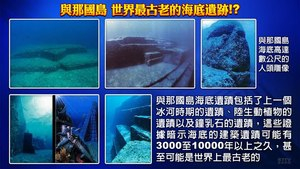
This new discovery not only coincides with the "MU continent" proposed by American scholar James Churchward, but also reveals the fact hinted at by local legends of "subsidence of geological strata" thousands of years ago. It is generally believed that the discovery of the Sakiyama pyramid may be a key to unraveling the mystery of the "vanished MU continent and MU civilization".
Taiwan: Seven Star Mountain Pyramid is older than Egypt
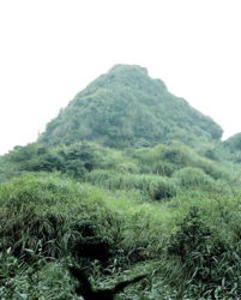
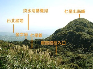
In late 1994, a triangular pyramid was discovered on the highest peak of Yangmingshan in the suburbs of Taipei - Seven Star Mountain, also known as Mt. Qixing. Viewed from the main peak of Seven Star Mountain, the pyramid apex is connected to the saddle of Nanshan Mountain in the south, forming a north-south axis. The height of the structure is about thirty meters, and its exterior is covered with green vegetation due to its age. There are entrances on the south and east sides, but some parts have collapsed and are too muddy to enter.
Ketagalan historian Lin Sheng-yi and Associate Professor He Xian-rong of the Taiwan Ancient Civilization Research Office believe that this pyramid was left behind by the Ketagalan people 30,000 to 50,000 years ago as part of their megalithic civilization, which is three to five thousand years older than the pyramids in Egypt. However, the purpose of both pyramids was to construct an energy field and collect cosmic energy to create a non-decaying environment at the center of the pyramid.
The surface of the pyramid is covered with a large amount of vegetation and sand, and it has been eroded by wind and rain, making many areas uneven. Professor He Xian-rong said that after removing the covering, it can be seen that the slope surface is made up of rocks that were clearly stacked by humans, rather than natural formation.
One hundred meters directly north of the pyramid, there is a steep pile of rocks about five meters high, facing the pyramid. On the raised base of soil, there are three stone tablets arranged in a triangle, with the middle one larger than the two on either side and symmetrical with the pyramid. Although there is no writing on the tablets, Lin Sheng-yi believes that they are a traditional form of monument for the indigenous Ketagalan people.
In front of the stone tablets, there is a plaza with a crescent-shaped depression about ten meters in diameter, surrounding the stone tablets. After rainfall, it becomes a "crescent moon pool." Its curved surface faces inward towards the central stone tablet, and the plaza seems to be a site arranged around the stone tablets. Scholars believe it is a place where ancient people offered sacrifices to the heavens, called the "heavenly altar."
About 20 meters behind the altar for worshiping the heavens, there is an ancient megalithic monument that appears to have been cut and stacked by hand, possibly an artificial altar where offerings were placed during worship.
Several pyramids have been discovered in the Pacific Rim region. Supporting scholars believe that while these pyramids, along with the Qixing Mountain pyramid, the sunken city of Huwei in Penghu, and the Sasaki Pyramid, may not be ruins from the same time period, they are certainly part of the disappeared "Mu continent" ancient civilization.
Pakistan: Chogolisa Peak and the Pyramid
Chogolisa Peak is located on the border between China and Pakistan, with an altitude of 8611 meters. "Chogolisa" means "tall and magnificent" in Tajik, and it is also known as "K2", the main peak of the Karakoram mountain range and the second highest peak in the world. The peak is pyramid-shaped with towering ice cliffs, steep slopes, and a north face that is as steep as a knife and has an average slope of over 45 degrees, with a vertical difference of 4700 meters, making it the peak with the greatest vertical difference on earth. Is it true that the treasure trove of the gods is hidden in this pyramid-shaped mountain range?
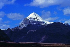
Ralph Ellis, a Jewish scholar and explorer from the UK, argues in his book "K2 and the Pyramids of Egypt" that the pyramids in Egypt are not pharaohs' tombs, but rather replicas of the main peak of the Karakoram mountain range.
The biggest secret of the Egyptian pyramids is that they contain an accurate world map. By mathematical calculations, one can discover that the "Temple of Knowledge" in Western legends is located at the main peak of the Karakoram mountains, the Chogolisa peak. Ancient Egyptian legends always refer to the East, not the West or the Atlantic.
Ralph Ellis believes that the pyramids were built in imitation of mountains, especially the most famous Giza pyramids on the Giza plateau in Egypt, which specifically imitate Chogolisa and its surroundings. By comparing aerial photographs with the Giza pyramids, this result can be obtained using the simplest mathematical formulas or by measuring with one's own feet. This means that at least 10,000 to 5,000 years ago, the ancient Egyptians had already ventured to the Karakoram mountain range!
Using mathematical calculations, he determined that the Great Pyramid of Giza, when turned upside down, forms a map with its central axis pointing not to the Himalayas, but to the Chogolisa Peak in the Karakoram Range. Its shape is identical to that of the pyramid except for its size, with the base of the mountain forming a square and its four main ridges extending towards the peak in the northwest, northeast, southeast, and southwest directions. It seems to have been positioned using a compass, and its shape and color are also identical to those of the Great Pyramid. Even the 14-degree slant of the Great Pyramid's base towards the right is exactly the same as the one on the Godwin-Austen Glacier flowing down from K2.
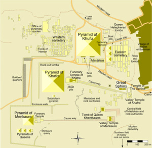
And the small mountain peak on the left side of the K2 base, Angles Peak, is also pyramid-shaped, which is clearly an imitation of the three small pyramids. The K2 base covers an area of 27 square kilometers, and with the causeway, it may require several hundred square kilometers.
The surrounding environment of K2 is also very similar to that of the Giza plateau, including the three small pyramids, which are actually imitations of some small mountain peaks that extend in the same direction as K2. What is particularly convincing is that the roads formed by the large mountain gullies around K2 are almost the same as those on the Giza plateau.
According to Ralph Ellis, "The similarity between the two buildings is so amazing that it is as if K2 was uprooted and placed on the Giza Plateau, they are almost identical."
In the article "Distribution of Neolithic Maps," it is stated that people can clearly see the absence of human settlements in the Tarim Basin, and that the few Neolithic settlements are located closer to the Kunlun Mountains near the Qogir Peak, rather than scattered below the Kunlun Mountains. This argues that K2 is located precisely at the center of this triangular area and may be the best landing point for the "Temple of Knowledge."
Chinese people are no strangers to the Kunlun Mountains. Most of China's mythology is related to the Kunlun Mountains, and how many mysteries are buried at the top of those high mountains! In ancient China, most people chose to face west after death, and the Kunlun Mountains are located in the west of China. Correspondingly, if ancient Egyptians had a choice of direction after death, it would certainly be towards the east! The Kunlun Mountains are to the east of Egypt!
Perhaps it was a great flood 5,000 years ago or even earlier that brought together the gods of the East and West to the Kunlun Mountains, the abode of the heavenly gods, to escape the flood and gain knowledge, instruction, and will from the heavenly gods, and many things happened that we do not know. After the flood receded, they returned to their homelands to rebuild their own civilizations. Because their interpretations of the divine oracles differed, the ancient myths of various ethnic groups have similarities and differences.
A more insightful analysis of the Great Flood and Kunlun Mountain can be found in the Falun Dafa books, “Fa Teaching Given in New York City”, and “(Teaching the Fa at the Founding Ceremony of the Singaporean Falun Dafa Association).”
“During the last great flood—the last human civilization was destroyed by a great flood—all the big mountains on the earth that had elevations of less than two thousand meters were submerged, and only the people who lived above two thousand meters survived. The story of Noah’s Ark is true. During that great flood the Western culture was completely destroyed, and the Eastern culture was also in ruins. But the mountain people who lived in the areas of the Himalayan and Kunlun Mountains and who were like rural people were fortunate enough to escape—the Chinese people who lived in the Kunlun Mountains survived. At that time the Eastern culture was well-developed; Yellow River Diagram (Hetu), Luo River Writings (Luoshu), Book of Changes (I Ching), Tai Chi, Eight Trigrams (Bagua), and so on were inherited from the past. People say that they were created by this person or that person of a later generation. Those people only modified them and made them public again. They weren’t created by those people at all, and were all from prehistoric cultures.” (Fa Teaching Given in New York City).
“You know, in the early period of the current human civilization—four or five thousand years ago—our Earth experienced a great flood, and it engulfed the entire Caucasian civilization in Europe. Of course, precious little was left, though one could still see glimpses of the prehistoric past from the artifacts that remained. For instance, evidence of the existence of prehistoric civilizations can be seen in archaeological finds involving the culture of ancient Greece. In the East, relatively more things survived the great flood. Everyone knows the story of Yu the Great controlling the flood. The flood at the time was fierce, and when the water receded, Yu the Great led people to guide the water out of the flooded land. This was documented in history. The ancient human civilization at that time—the one in the last cycle—was destroyed by the huge flood, but many of the ancestors of the Chinese people survived the huge flood, and relatively more artifacts were left behind. In comparison, fewer Westerners survived. That is why the Western culture of today is a completely new one, one that is completely new and without any trace of ancient history. Thus, the ancient civilization of China has a deep-rooted history, and took a different path than modern science.” (Teaching the Fa at the Founding Ceremony of the Singaporean Falun Dafa Association).
“So in these ancient civilizations, there are many things that present-day people are still unable to understand and that are disassociated from modern culture. So, many people, including Westerners, know that in China there are many, many mysterious things—things that today’s people cannot understand. Chinese people themselves know this. In the land of China, there are many things of ancient culture that cannot be understood by modern people. Some people have heard about them and seen them, yet they cannot explain them, and no one has yet made public these ancient things and introduced them to people. Since more of the ancestors of the Chinese people survived [back during the flood], a portion of ancient culture has survived.” (Teaching the Fa at the Founding Ceremony of the Singaporean Falun Dafa Association).
“In the past, the ancient Chinese race was not concentrated in what is now the Yellow River valley; instead, it was located in the Xinjiang region. The most prosperous period for that civilization occurred in that region. Since Mt. Kunlun was nearby, the terrain in the neighboring areas was quite high. The water level of the great flood that year reached as high as two thousand meters, submerging the entire Earth. But when the great flood was unleashed, many people survived by escaping to Mt. Kunlun, preserving some things of the ancient culture. They include, for instance, Hetu and Luoshu diagrams, the Taiji, the original Eight Trigrams (bagua), and other things that some people in China still can’t understand, as well as some ancient forms of qigong that today’s people know of.” (Teaching the Fa at the Founding Ceremony of the Singaporean Falun Dafa Association).
Please refer to the website for information about Falun Dafa's literature: http://www.falundafa.org
To be continued.
Chinese version: https://big5.zhengjian.org/node/75980